Tuesday, 23 June 2020

Viking History Is Melting Away in Greenland

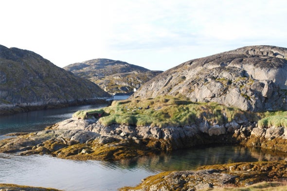
One of the archaeological sites included in the study is located at Kangeq in the archipelago outside of Nuuk in West Greenland. Credit: Jørgen Hollesen National Museum of Denmark

Lining the fjords of Greenland are remnants of Viking-era Norse outposts that flourished for less than 500 years before they were mysteriously abandoned. And now this lost culture is experiencing a second disappearance, triggered by climate change.

Of all the archaeological sites in Greenland, Norse settlements are at the most risk of rotting away as the Arctic warms, according to new research published Thursday in Scientific Reports. The study estimates that up to 70 percent of the organic material in these sites could decay by 2100.

What stands to be lost is a unique record of remarkably preserved material: hair, textiles, human and animal bones, woods, hides, leathers. As the soil warms up and the number of frost-free days increases, microbes attack these fragile organics, leaving only rot behind. The changes are already happening near Greenland’s capital city of Nuuk, says lead study author Jørgen Hollesen, a senior researcher at the National Museum of Denmark. “Here we have some sites where we know that they found a lot of artifacts, a lot of bones, 40 years ago—but today we don’t see that much left,” he says. “There were bones at some point, but now it’s just this fine-grained mush.”

Read the rest of the article

Sunday, 21 June 2020

History in Ice

(Dr. Nicole Spaulding, Climate Change Institute, University of Maine)
Colle Gnifetti glacier, Switzerland

Lead pollution levels from the Middle Ages preserved in an ice core taken from Colle Gnifetti glacier in the Swiss Alps reflect political upheaval in England, some 500 miles away, a multidisciplinary research team has found. In addition to studying archaeological data and tax records, the researchers used lasers to measure how lead levels in the core changed from year to year. They observed a major spike in lead pollution during the reign of the English Angevin kings—Henry II, Richard I, and John—between 1154 and 1216, when economic growth led to an increase in silver and lead production from British mines. Lead particles from the extraction and smelting processes were carried southeast by weather patterns, and traces of the metal were trapped in Swiss glaciers.

Read the rest of this article...

Saturday, 13 June 2020

Tree-ring analysis has solved many historical mysteries

Tree rings are now considered to be one of the most revealing of all climatic indicators. Getty Images

Depopulation, pandemics, the rise and fall of empires — all can be explained by dendrochronology, according to Valerie Trouet

History is only as good as its sources. It is limited largely to what has survived of written records, and in prehistory to random fragments unearthed by archaeologists and paleontologists. Climate history is no different. As the effects of global warming accelerate, it becomes ever more urgent to reassemble what we can of the atmospheric conditions of the past to gather evidence from wherever it may be.

Glacial ice cores are one place, with their frozen snapshots of long-ago air and traces of ash and pollen and greenhouse gases such as carbon dioxide or methane. Other climate proxies include the annual accretion of stalagmites, the growth of corals and the incremental layers of bone in the ears of fish. But in recent decades, tree rings have emerged as one of the most precise and revealing of all paleoclimatic indicators.

Each growing season, a tree adds an outer layer of cambium to its core of dead wood. How much is added is a function of thermal and pluvial conditions. The exact width of the ring and its microscopic structure give a very clear picture of the weather during a period of a few warm months, like a postcard from a distant summer.

Read the rest of this article...

Thursday, 28 May 2020

Melting ice reveals an ancient, once-thriving trade route

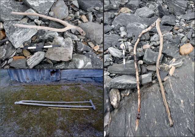
Upper left: an object interpreted as a tong (a clamp for holding fodder on a sled or wagon), dated to the Late Roman Iron Age; right: a similar, undated object, also from the pass area; lower left: a historical example from Uppigard Garmo, pre-dating c. 1950. Credit: Glacier Archaeology Program & R. Marstein/Lars Pilø et al.

High in the mountains of Norway, melting ice has led to the discovery of an ancient remote mountain pass, complete with trail markers and artifacts from the Roman Iron Age and the time of the Vikings. The remains reveal this route served a dual function historically: It was once a significant passageway for moving livestock between grazing sites as well as for inter-regional travel and trade. This particular receding ice patch is known as Lendbreen, and because of its tame geologic features, hundreds of artifacts have been pristinely preserved. Most are from the Viking Age, providing an odd inland perspective to the age-old tales of their audacious maritime journeying.

Glaciers and ice patches throughout the world's high mountain regions are receding, leaving behind precious artifacts, like Ötzi the ice man and his tool kit, that have been buried under ice for centuries. The rate of melt has been accelerating over the past few decades as a result of the warming climate. In the 1980s, glaciers lost less than a foot of ice per year, on average. That number increased every decade so that by 2018, glaciers around the world were losing mass at a pace of three feet per year. This rise in melt drastically propelled the field of glacier and ice patch archaeology—especially in Scandinavia, the Alps and North America—as archaeologists raced to collect artifacts uncovered by this process.

Read the rest of this article...

Monday, 25 May 2020

Britain’s historic ghost villages

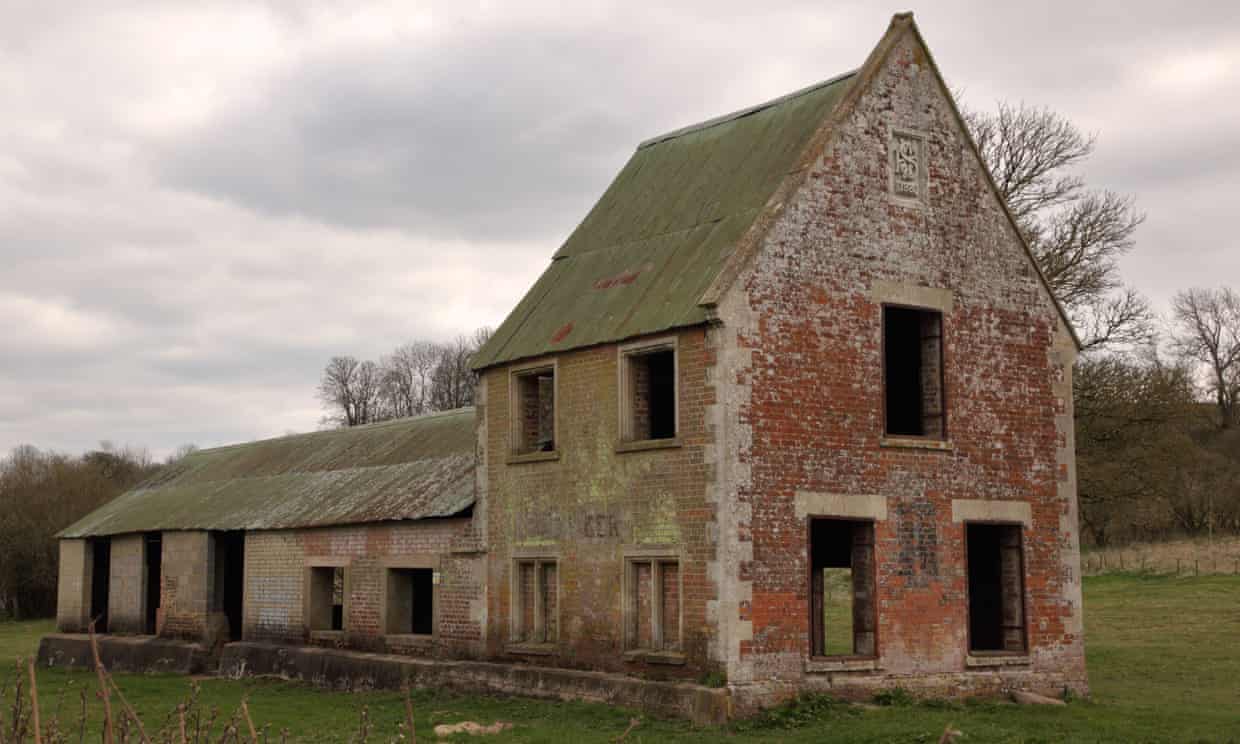
The former Seagram’s Farm in Imber, the Wiltshire village requisitioned for second world war training. Photograph: Jane Tregelles/Alamy

Most of Britain’s ghost towns were abandoned after a previous pandemic – the Black Death – wiped out entire populations from hundreds of villages. The greatest losses were in Norfolk and Suffolk, often the landing points for plague-infested ships.

Coastal erosion also contributed to settlements in these counties disappearing into the sea. The most famous, Dunwich, was a thriving port, equivalent in size to 14th-century London, before the sea swallowed it and its eight churches, earning Dunwich the name England’s Atlantis. While the majority of British “ghost villages” have all but disappeared, a few still offer rewards – and warnings – for the curious.

At the outbreak of the second world war, the Ministry of Defence commandeered several villages for target practice and manoeuvres. Imber, in Wiltshire, is still used for this purpose. On Open Days, visitors can wander deserted streets lined with skeletal houses, a Norman church and a bullet-riddled pub (Imber hopes to be open for August bank holiday this year).

Read the rest of this article...

Friday, 22 May 2020

Migration patterns reveal an Eden for ancient humans and animals

An artist rendering of the Palaeo-Agulhas Plain during the Pleistocene.

Home to some of the richest evidence for the behavior and culture of the earliest clearly modern humans, the submerged shelf called the Palaeo-Agulhas Plain (PAP) once formed its own ecosystem. Co-author Curtis Marean, Ph.D., Arizona State University, has worked with teams of scientists for decades to reconstruct the locale back into the Pleistocene, the time period that spanned from 2.6 million to 11,700 years ago.

In this study, the researchers looked specifically at antelope migratory patterns at Pinnacle Point. This series of cave sites that sit on the modern South African coast offers archaeological materials from humans who were living and hunting there back to 170,000 years ago.

"During glacial cycles, the coastal shelf was exposed," said Hodgkins. "There would have been a huge amount of land in front of the cave sites. We thought it was likely that humans and carnivores were hunting animals as they migrated east and west over the exposed shelve."

Read the rest of this article...

Endangered cultural heritage on the seafloor: Underwater archaeology in the North and Baltic Seas

Credit: Sarah Katharina Heuzeroth

In many regions of the world, the seafloor contains a fascinating archive of human history. This also applies to the North Sea and Baltic Sea. The German National Academy of Sciences Leopoldina has released the discussion paper Traces under Water – Exploring and Protecting the Cultural Heritage in the North Sea and Baltic Sea to raise awareness of the value of the cultural heritage found in the depths of the North Sea and Baltic Sea. The paper’s authors describe the importance of this heritage and recommend measures for effectively protecting it.

The authors of the publication illustrate the profound importance of the cultural heritage in the North Sea and Baltic Sea for archaeological research in Germany and the other states bordering the two seas. According to the authors, in Germany, the underwater cultural heritage has been explored much less than that on land.

At the same time, there is a lot of pressure to economically exploit the seas and the seafloors – a trend that is only expected to increase. Thus, two primary objectives are laid out in the discussion paper. 

Firstly, the investigations of the cultural heritage in the North Sea and Baltic Sea should be comprehensive and be carried out to the same high scientific standard as those on land. Secondly, Germany should establish protective measures in its exclusive economic zone which are just as effective as those which have long been in effect on land. 

Read the rest of this article...