Thursday 28 May 2020

Melting ice reveals an ancient, once-thriving trade route

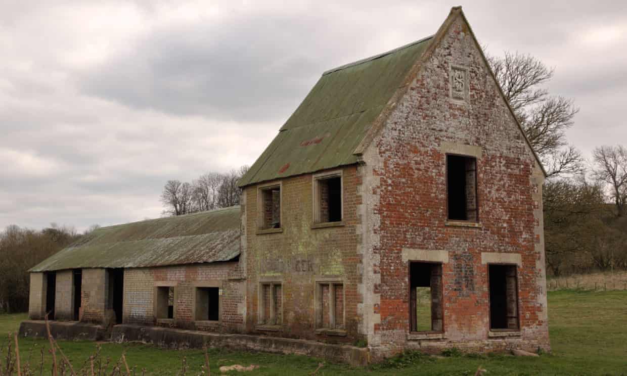
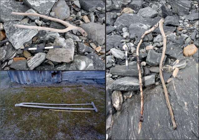
Upper left: an object interpreted as a tong (a clamp for holding fodder on a sled or wagon), dated to the Late Roman Iron Age; right: a similar, undated object, also from the pass area; lower left: a historical example from Uppigard Garmo, pre-dating c. 1950. Credit: Glacier Archaeology Program & R. Marstein/Lars Pilø et al.

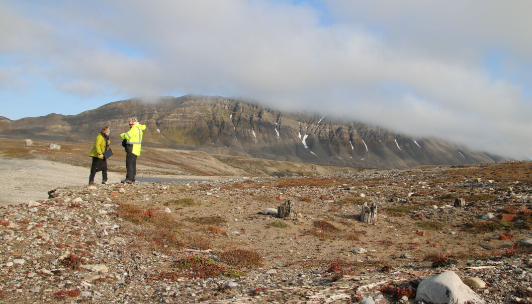
High in the mountains of Norway, melting ice has led to the discovery of an ancient remote mountain pass, complete with trail markers and artifacts from the Roman Iron Age and the time of the Vikings. The remains reveal this route served a dual function historically: It was once a significant passageway for moving livestock between grazing sites as well as for inter-regional travel and trade. This particular receding ice patch is known as Lendbreen, and because of its tame geologic features, hundreds of artifacts have been pristinely preserved. Most are from the Viking Age, providing an odd inland perspective to the age-old tales of their audacious maritime journeying.

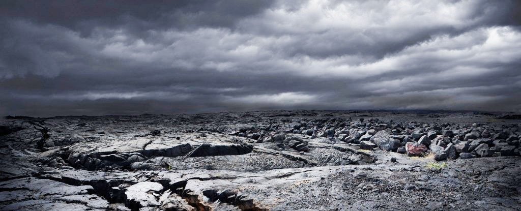
Glaciers and ice patches throughout the world's high mountain regions are receding, leaving behind precious artifacts, like Ötzi the ice man and his tool kit, that have been buried under ice for centuries. The rate of melt has been accelerating over the past few decades as a result of the warming climate. In the 1980s, glaciers lost less than a foot of ice per year, on average. That number increased every decade so that by 2018, glaciers around the world were losing mass at a pace of three feet per year. This rise in melt drastically propelled the field of glacier and ice patch archaeology—especially in Scandinavia, the Alps and North America—as archaeologists raced to collect artifacts uncovered by this process.

Read the rest of this article...

Monday 25 May 2020

Britain’s historic ghost villages

The former Seagram’s Farm in Imber, the Wiltshire village requisitioned for second world war training. Photograph: Jane Tregelles/Alamy

Most of Britain’s ghost towns were abandoned after a previous pandemic – the Black Death – wiped out entire populations from hundreds of villages. The greatest losses were in Norfolk and Suffolk, often the landing points for plague-infested ships.

Coastal erosion also contributed to settlements in these counties disappearing into the sea. The most famous, Dunwich, was a thriving port, equivalent in size to 14th-century London, before the sea swallowed it and its eight churches, earning Dunwich the name England’s Atlantis. While the majority of British “ghost villages” have all but disappeared, a few still offer rewards – and warnings – for the curious.

At the outbreak of the second world war, the Ministry of Defence commandeered several villages for target practice and manoeuvres. Imber, in Wiltshire, is still used for this purpose. On Open Days, visitors can wander deserted streets lined with skeletal houses, a Norman church and a bullet-riddled pub (Imber hopes to be open for August bank holiday this year).

Read the rest of this article...

Friday 22 May 2020

Migration patterns reveal an Eden for ancient humans and animals

An artist rendering of the Palaeo-Agulhas Plain during the Pleistocene.

Home to some of the richest evidence for the behavior and culture of the earliest clearly modern humans, the submerged shelf called the Palaeo-Agulhas Plain (PAP) once formed its own ecosystem. Co-author Curtis Marean, Ph.D., Arizona State University, has worked with teams of scientists for decades to reconstruct the locale back into the Pleistocene, the time period that spanned from 2.6 million to 11,700 years ago.

In this study, the researchers looked specifically at antelope migratory patterns at Pinnacle Point. This series of cave sites that sit on the modern South African coast offers archaeological materials from humans who were living and hunting there back to 170,000 years ago.

"During glacial cycles, the coastal shelf was exposed," said Hodgkins. "There would have been a huge amount of land in front of the cave sites. We thought it was likely that humans and carnivores were hunting animals as they migrated east and west over the exposed shelve."

Read the rest of this article...

Endangered cultural heritage on the seafloor: Underwater archaeology in the North and Baltic Seas

Credit: Sarah Katharina Heuzeroth

In many regions of the world, the seafloor contains a fascinating archive of human history. This also applies to the North Sea and Baltic Sea. The German National Academy of Sciences Leopoldina has released the discussion paper Traces under Water – Exploring and Protecting the Cultural Heritage in the North Sea and Baltic Sea to raise awareness of the value of the cultural heritage found in the depths of the North Sea and Baltic Sea. The paper’s authors describe the importance of this heritage and recommend measures for effectively protecting it.

The authors of the publication illustrate the profound importance of the cultural heritage in the North Sea and Baltic Sea for archaeological research in Germany and the other states bordering the two seas. According to the authors, in Germany, the underwater cultural heritage has been explored much less than that on land.

At the same time, there is a lot of pressure to economically exploit the seas and the seafloors – a trend that is only expected to increase. Thus, two primary objectives are laid out in the discussion paper. 

Firstly, the investigations of the cultural heritage in the North Sea and Baltic Sea should be comprehensive and be carried out to the same high scientific standard as those on land. Secondly, Germany should establish protective measures in its exclusive economic zone which are just as effective as those which have long been in effect on land. 

Read the rest of this article...

Sunday 17 May 2020

Drowned Paleo-Agulhas Plain was an Eden for Early humans


The Paleo-Agulhas Plain in South Africa had diverse, verdant ecosystems and abundant game for early Humans.
In contrast to ice age environments elsewhere on Earth, it was a lush environment with a mild climate that disappeared under rising sea levels around 11,500 years ago.

An interdisciplinary, international team of scientists has now brought this pleasant cradle of humankind back to life in a special collection of articles that reconstruct the paleoecology of the Paleo-Agulhas Plain, a now-drowned landscape on the southern tip of Africa that was high and dry during glacial phases of the last 2 million years.

“These Pleistocene glacial periods would have presented a very different resource landscape for early modern human hunter-gatherers than the landscape found in modern Cape coastal lowlands, and may have been instrumental in shaping the evolution of early modern humans,” said Janet Franklin, a distinguished professor of biogeography in the department of Botany and Plant Sciences at UC Riverside, an associate member of the African Centre for Coastal Palaeoscience at Nelson Mandela University in South Africa, and co-author of several of the papers.

Read the rest of this article...

Thursday 14 May 2020

Study suggests remnants of human migration paths exist underwater at 'choke points'

Artist’s re-creation of the first human migration to North America from across the Bering Sea
[Credit: DEA Picture Library/Deagostini/Getty Images]

Today, sea-level rise is a great concern of humanity as climate change warms the planet and melts ice sheets in Greenland and Antarctica. Indeed, great coastal cities around the world like Miami and New Orleans could be underwater later in this century. But oceans have been rising for thousands of years, and this isn't the first time they have claimed land once settled by people. A new paper published in Geographical Review shows evidence vital to understanding human prehistory beneath the seas in places that were dry during the Last Glacial Maximum. Indeed, this paper informs one of the "hottest mysteries" in science: the debate over when the first Asians peopled North America.

The researchers behind the paper studied "choke points" -- narrow land corridors, called isthmuses but often better known for the canals that cross them, or constricted ocean passages, called straits. Typically isthmuses would have been wider 20,000 years ago due to lower sea levels, and some straits did not even exist back then.

"We looked at nine global choke points -- Bering Strait, Isthmus of Panama, Bosporus and Dardanelles, Strait of Gibraltar, straits of Sicily and Messina, Isthmus of Suez, Bab al Mandab, Strait of Hormuz and Strait of Malacca -- to see what each was like 20,000 years ago when more water was tied up in ice sheets and glaciers," said lead author Jerry Dobson, professor emeritus of geography at the University of Kansas and president emeritus of the American Geographical Society. "During the Last Glacial Maximum, the ocean surface was 410 feet lower than today. So, worldwide the amount of land that has been lost since the glaciers melted is equivalent to South America."

Read the rest of this article...

Wednesday 13 May 2020

River valley flooding destroys archaeological sites, uncovers others


Flooding in the Williams Lake River Valley has washed away thousands of years of Indigenous history while unearthing others.

Since a pollution abatement order was issued to the City of Williams Lake by the Williams Lake Indian Band (WLIB) on April 30, WLIB manager of title and rights Whitney Spearing said DWB Consulting from Lac La Hache has been working with WLIB, the City, and Ministry of Environment to facilitate environmental testing including water and soil sampling.

Spearing added Sugarcane Archaeology was issued an emergency permit from the Archaeology Branch of British Columbia on May 1.

“So we have a permit now in place to help actively facilitate those emergency works,” she said. “What that means is we are on the ground and we are assessing not only the environmental damage and stream damage of natural portions but obviously disturbances have been created as a result of trying to get access into the lagoons and get power restored and get that cap in place for the effluent so we are in the valley assessing those areas as well as some of the road widening that has happened to get rock trucks in and out of that area.”

Read the rest of this article...

Tuesday 12 May 2020

How Climate Change is threatening Heritage in the Arctic

On route to field work, the scientists stumbled upon the remains of a Russian hunting cabin from the 1800s. These remains have been known for a while, but not its quickly deteriorating current state. (Photo: Thomas Wrigglesworth/NIKU)

As the Arctic experiences rising temperatures, thawing permafrost and increased rainfall, cultural heritage sites and objects are under threat of disintegration.

Not only are weather conditions changing, but tourism and growth have led to further strain on the natural environment. Researchers involved with the interdisciplinary project CULTCOAST are examining climate effects on coastal cultural heritage in the High North areas of Norway but also in relation to the influence of tourism.

The recent discovery of an unknown grave
While conducting fieldwork for the project, researchers recently discovered a partially eroded, unknown grave near other known heritage sites in the Russekeila area on Svalbard’s Kapp Linné.

“This is a classic example of a heritage object that is about to completely disappear before we have the possibility of learning anything from it. And that is very sad,” says project leader Vibeke Vandrup Martens of the Norwegian Institute for Cultural Heritage Research (NIKU). She says the grave would eventually end up in the sea, but this process is hastened by climate changes.

It was found at the point where the Linné -river meets the fjord, and is an unusual location for a grave, sparking theories about the circumstances around the burial.

Read the rest of this article...

Monday 11 May 2020

Climate change could unlock Ice Age bugs that spark the world’s next pandemic

Humans could be exposed to ‘eradicated’ or completely new microbes because of climate change thawing (Picture: Getty)

Dr Dennis Carroll – who appears in the Netflix documentary Pandemic – said we should be ‘should be exceedingly cautious about underestimating the potential threats’ that reborn germs could pose. Speaking exclusively to Metro.co.uk, Dr Carroll – dubbed ‘the man who saw the pandemic coming’ – also warned that diseases spread from wildlife should also be seen as a global health concern following the coronavirus outbreak. His intervention comes as scientists today published new research on how rising temperatures melting ‘permafrost’ Arctic soil could give a new lease of life to dormant microbes. Those bacteria and viruses, frozen for thousands of years, could potentially include diseases which humanity has previously ‘eradicated’ – and ones we have never encountered. Dr Carroll explained: ‘The world is faced with the very real prospect that ancient microbes which have long lay dormant beneath the frozen tundra will be given a new life with climate change and the thawing of the Arctic north. 

Read the rest of this article...

Rewilding: lessons from the medieval Baltic crusades

Bison in the forest of Białowieża. © Magnus Elander

The Forest of Białowieża, which straddles the border of Poland and Belarus, is unique in Europe: it is incredibly ancient. Woodland has been continuously present there for some 12,000 years. With the protection of 6059 hectares from human disturbance within the Polish national park, as well as the return of its iconic European bison herds from the brink of extinction, the forest is widely regarded as a model for restoring biodiversity or “rewilding”, which areas across Europe are trying to emulate.

Human memories are remarkably short – often only a generation or so. What we remember as “natural” landscape is often what we remember experiencing as a child. This makes conservation and landscape management particularly subject to “shifting baseline syndrome” – a psychological phenomenon which describes how each new generation accepts as natural or normal the situation in which it was raised. This means that significant time depth is rarely considered in future planning. But understanding environmental change, and planning for the future impact of our species, must include a long-term perspective.

There are ways around this. Archaeologists such as ourselves are uniquely placed to understand how fluctuations in human activity can affect the environment over much longer time periods. It is well known, for example, that our species’ mastery of farming enabled our populations to grow, with resulting deforestation and loss of biodiversity. This can be mapped through pollen coring, and the study of archaeological plant and animal remains. These techniques have become more precise in our lifetime, especially with advances in radiocarbon dating.

Read the rest of this article...

Stone Tools Show How Humans Survived a Supervolcano Eruption 74,000 Years Ago

(Chris Clor/Getty Images)

Of all the volcanic eruptions to shake our planet in the last 2 million years, the Toba super-eruption in Sumatra, Indonesia, was one of the most colossal. But it may not have been the global catastrophe we once thought it was.

The massive eruption happened roughly 74,000 years ago, spewing roughly 1,000 times as much rock as the 1980 eruption of Mt St Helens. For a while there, some thought the fall-out was so extreme, it triggered a decade-long "volcanic winter" and a millenia-long glacial period.

This so-called Toba catastrophe theory left the global human population with just a few thousand survivors. Except, that's probably an exaggeration.

In recent times, archaeological evidence in Asia and Africa has suggested that while the eruption was indeed tremendous, the consequences were not so apocalyptic after all, and it certainly didn't leave humans on the brink of extinction.

Now, an ancient and "unchanging" stone tool industry, uncovered at Dhaba in northern India, suggests instead that humans have been present in the Middle Son Valley for roughly 80,000 years, both before and after the Toba eruption.

Read the rest of this article...

Saturday 9 May 2020

Dunwich – The medieval town lost at sea

Chapel of St James’ Leper Hospital, Dunwich St James’ Hospital was a C12 leper hospital located just to the west of the medieval coastal town of Dunwich.

Dunwich is a small rural village located on the Suffolk coast in England. Visitors will find a quaint English pub, tea rooms and a pebble beach popular with holiday makers.
At first glance, there’s nothing overly remarkable about this picturesque setting, but beneath the surface Dunwich has a unique story to tell that spans centuries….

The earliest evidence of occupation around the Dunwich area starts in the Roman period, with scant but suggestive evidence of a large settlement. The Anglo-Saxon chronicler Bede referred to “Dunmoc” as a “Civitas”, with archaeological discoveries that includes a Roman tumulus and masonry trawled from the nearby seabed.

The Roman document, ‘Notilia Dignitatum’ even refers to a late Roman fort or station in the area, but due to the continual coastal erosion, any surviving remains of the fort or settlement would be hundreds of metres out to sea.

Read the rest of this article...

Thursday 7 May 2020

Historic shipwreck uncovered on Victorian beach

The Inverloch shipwreck is being uncovered by sand erosion on a country Victorian beach. (9News)

The largest section of Inverloch's historic shipwreck has been revealed, with more than 30 centimetres of sand eroding away to uncover more of the wreckage.

On December 12, 1863, the Amazon departed Melbourne for Mauritius with a cargo of salted meats. Only four days later it washed up on Inverloch surf beach, after encountering a storm on Bass Strait.
Since then, the 157-year-old shipwreck has slowly been uncovered due to erosion.

 "There has been a lot of locals walking on the beach trying to keep themselves fit and healthy, and everyone is just amazed with what they are seeing," secretary of Amazon 1863 Project Inc, Karyn Bugeja said.

"At the moment there is more uncovered and it is telling a completely different story to what we thought up until 48 hours ago."

Read the rest of this article...

Wednesday 6 May 2020

Archaeology offers clues to pandemic rebounds from the past


As the COVID-19 pandemic redefines what we think of as "normal," archaeology and ancient history can provide some consolation about the great adaptability of our species.

Flinders University archaeologist and ancient historian Dr. Ania Kotarba points to responses of extreme historical events that have threatened homo sapiens in the past as evidence that society—and the economy—can, and will, spring back again.

Dr. Kotarba researches global connectivity in the past through studying ancient international trade routes and human adaptation to extreme change.

She says the processes of urbanization, population growth and proto-globalization in the ancient world initially allowed outbreaks of infectious diseases and epidemics. These often surprisingly resulted in boosting the economy.

Read the rest of this article...

How did Iron Age Society Cope with Crisis?

The Cairns Broch looking across to the North Sea

There can be no doubt that we are experiencing a major international crisis that affects all our lives, all of the time at the moment.

It would appear that this crisis may indeed change the way we do things for some considerable time and may even change our society permanently.

As a society we are aided in our understanding of the Covid-19 emergency and the way we can address the social, economic and political effects through our use of technology…..but what of society in the Iron Age? How did they cope with emergencies that affected their way of life? Did they change their way of doing things permanently?

Read the rest of this article...

Monday 4 May 2020

Archaeology, climate, and global change in the Age of Humans


We live in an age characterized by increasing environmental, social, economic, and political uncertainty. Human societies face significant challenges, ranging from climate change to food security, biodiversity declines and extinction, and political instability. In response, scientists, policy makers, and the general public are seeking new interdisciplinary or transdisciplinary approaches to evaluate and identify meaningful solutions to these global challenges. Underrecognized among these challenges is the disappearing record of past environmental change, which can be key to surviving the future. Historical sciences such as archaeology access the past to provide long-term perspectives on past human ecodynamics: the interaction between human social and cultural systems and climate and environment. Such studies shed light on how we arrived at the present day and help us search for sustainable trajectories toward the future. Here, we highlight contributions by archaeology—the study of the human past—to interdisciplinary research programs designed to evaluate current social and environmental challenges and contribute to solutions for the future. The past is a multimillennial experiment in human ecodynamics, and, together with our transdisciplinary colleagues, archaeology is well positioned to uncover the lessons of that experiment.

Read the rest of this article...