Wednesday 2 December 2020

Melting ice patch in Norway reveals large collection of ancient arrows


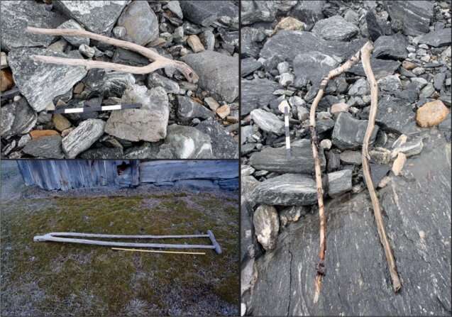
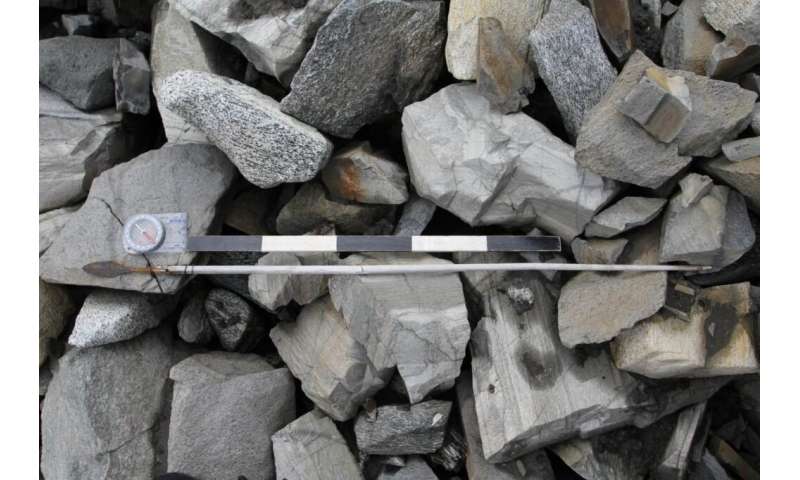
An arrow from c. AD 700 as it was found lying on the stones in the scree, close to the melting ice. Credit: Innlandet Fylkeskommune

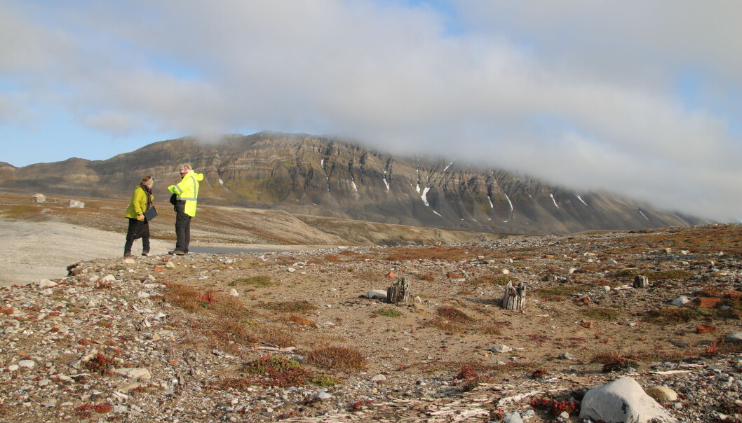
A team of researchers affiliated with a host of institutions in Norway and one in the U.K., has unveiled their findings after collecting and studying a very large number of ancient arrows they found near a melting ice patch in Norway's Jotunheimen Mountains. In their paper published in the journal The Holocene, the group describes how they kept their research secret to avoid the possibility of others contaminating the site and what they have learned about the arrows thus far.

Back in 2006, archeologist Reidar Marstein found an ancient shoe lying near a melting ice patch (which subsequent recent has shown to have formed approximately around 5600BC) in the Jotunheimen Mountains. The shoe was initially believed to have been from the Viking era, but subsequent study showed it to be approximately 3,300 years old.

Read the rest of this article...

Study Rewrites History of Ancient Land Bridge Between Britain and Europe

 New research suggests that climate change, not a tsunami, doomed the now-submerged territory of Doggerland


As recently as 20,000 years ago—not long in geological terms—Britain was not, in fact, an island. Instead, the terrain that became the British Isles was linked to mainland Europe by Doggerland, a tract of now-submerged territory where early Mesolithic hunter-gatherers lived, settled and traveled.

Doggerland gradually shrank as rising sea levels flooded the area. Then, around 6150 B.C., disaster struck: The Storegga Slide, a submarine landslide off the coast of Norway, triggered a tsunami in the North Sea, flooding the British coastline and likely killing thousands of humans based in coastal settlements, reports Esther Addley for the Guardian.

Historians have long assumed that this tsunami was the deciding factor that finally separated Britain from mainland Europe. But new archaeological research published in the December issue of Antiquity argues that Doggerland may have actually survived as an archipelago of islands for several more centuries.

Co-author Vincent Gaffney, an archaeologist at the University of Bradford, has spent the past 15 years surveying Doggerland’s underwater remains as part of the Europe’s Lost Frontiers project. Using seismic mapping, computer simulations and other techniques, Gaffney and his colleagues have successfully mapped the territory’s marshes, rivers and other geographical features.

Read the rest of this article...

Friday 30 October 2020

Archaeologists reveal human resilience in the face of climate change in ancient Turkey

Microscope image of Iron Age oak twig from Tell Tayinat in Hatay, Turkey.
Credit: Brita Lorentzen

An examination of two documented periods of climate change in the greater Middle East, between approximately 4,500 and 3,000 years ago, reveals local evidence of resilience and even of a flourishing ancient society despite the changes in climate seen in the larger region.

A new study led by University of Toronto and Cornell University archaeologists working at Tell Tayinat in southeastern Turkey, demonstrates that human responses to climate change are variable and must be examined using extensive and precise data gathered at the local level. The study highlights how challenge and collapse in some areas were matched by resilience and opportunities elsewhere.

Read the rest of this article...

Saturday 24 October 2020

CBA Festival of Archaeology

 The Council of British Archaeology’s Festival of Archaeology runs from 24 October to 1 November.  The situation with the Corona Virus means that many of the events will be digital, although there will be a number of live events. Please use the search facility on their webpage to see the various events that are offered.


You can find their website here…

Please note that EMAS archaeological Society has offered a quiz on little known archaeological sites in South East England.

You can find a link to the quiz on the EMAS home page here…

Test your knowledge and see how much you know about the archaeology of the area!

Friday 23 October 2020

Humans And Climate Drove Giants Of Madagascar To Extinction

Investigating the drivers of extinction: By analyzing stalagmites from the La Vierge Cave located
on Rodrigues the scientists reconstructed 8000 years of the region's past climate
[Credit: Hanying Li]

Nearly all of Madagascan megafauna - including the famous Dodo bird, gorilla-sized lemurs, giant tortoises, and the Elephant Bird which stood 3 meters tall and weighted close to a half ton - vanished between 1500 and 500 years ago. Were these animals overhunted to extinction by humans? Or did they disappear because of climate change? There are numerous hypotheses, but the exact cause of this megafauna crash remains elusive and hotly debated. 

The Mascarene islands east of Madagascar are of special interest because they are among the last islands on earth to be colonized by humans. Intriguingly, the islands' megafauna crashed in just a couple of centuries following human settlement. In a recent study published by Science Advances, a team of international researchers found that it was likely a "double whammy" of heightened human activities in combination with a particularly severe spell of region-wide aridity that may have doomed the megafauna. 

Read the rest of this article...

Surprising leap in ancient human technology tied to environmental upheaval


IMAGES FROM HUMAN ORIGINS PROGRAM, SMITHSONIAN

For 700,000 years, our species’ ancient relatives in East Africa led rather stable lives, relying on an enduring set of skills and survival strategies. They made large, simple hand axes from nearby stones, perhaps using them to slice up prey, cut down branches, or dig for tubers.

But by 320,000 years ago—around the same age as the earliest fossil evidence of Homo sapiens—these early humans drastically changed their ways. They began crafting smaller, more nimble points that could fly through the air as projectiles, some made from obsidian gathered from many miles away. They collected red and black pigments—substances later humans frequently used in symbolic ways such as cave painting.

Read the rest of this article...

East Africa Sediment Core Offers Human Evolution Clues


(Human Origins Program, Smithsonian)

Human Origins Program, Smithsonian)WASHINGTON, D.C.—According to a Science News report, a 450-foot-long sediment core from Kenya’s Koora Basin holds one million years of environmental data that could elucidate details of human evolution. Paleoanthropologist Rick Potts of the Smithsonian Institution said that chemical and microscopic studies of the layers in the sediment core revealed that some 400,000 years ago, volcanic eruptions reduced the size of lakes and the amount of available water, while the climate fluctuated dramatically. As large animals died out, they were replaced by smaller ones with more diverse diets, he explained. Between 500,000 and 320,000 years ago, hominins living at Kenya’s Olorgesailie site, which is located about 15 miles away from the core-drilling site, shifted from making cutting tools of local stone to the smaller, more carefully made objects made from imported materials that are characteristic of the Mesolithic. 

Read the rest of this article...

Monday 28 September 2020

Six African heritage sites under threat from climate change


From rock art in southern Africa to pyramids along the River Nile, humans have been leaving their mark across the continent for millennia.

But extreme weather events, the rise in sea levels and other challenges associated with the changing climate are threatening to destroy invaluable cultural landmarks, a recent study warns.

Writing in the Azania journal, researchers from the UK, Kenya and the US say that "significant intervention" is needed to save these heritage sites.

As if to underline the warning, in recent weeks archaeologists in Sudan have been trying to stop floodwater from the River Nile from reaching the UN-designated World Heritage Site at al-Bajrawiya.

Read the rest of this article...

Friday 11 September 2020

The Oldest Neanderthal DNA of Central-Eastern Europe


Image Credit : Jerzy Opioła

Around 100,000 years ago, the climate worsened abruptly and the environment of Central-Eastern Europe shifted from forested to open steppe/taiga habitat, promoting the dispersal of wooly mammoth, wooly rhino and other cold adapted species from the Arctic.

Neanderthals living in these territories suffered severe demographic contractions due to the new ecological conditions and only returned to the areas above 48° N latitude during climatic ameliorations. However, in spite of the discontinuous settlement, specific bifacial stone tools persisted in Central-Eastern Europe from the beginning of this ecological shift until the demise of the Neanderthals.

This cultural tradition is named Micoquian, and spread across the frosty environment between eastern France, Poland and the Caucasus. Previous genetic analyses showed that two major demographic turnover events in Neanderthal history are associated with the Micoquian cultural tradition. At ~90,000 years ago, western European Neanderthals replaced the local Altai Neanderthals population in Central Asia. Successively, by at least ~45,000 years ago, western European Neanderthals substituted the local groups in the Caucasus.

Monday 10 August 2020

Burnt remains from 586 BCE Jerusalem may hold key to protecting planet


A new analysis of 1st Temple-era artifacts, magnetized when Babylonians torched the city, provides a way to chart the geomagnetic field – physics’ Holy Grail – and maybe save Earth

The Bible and pure science converge in a new archaeomagnetism study of a large public structure that was razed to the ground on Tisha B’Av 586 BCE during the Babylonian conquest of Jerusalem. The resulting data significantly boosts geophysicists’ ability to understand the “Holy Grail” of Earth sciences — Earth’s ever-changing magnetic field.

“The magnetic field is invisible, but it plays a critical role in the life of our planet. Without the geomagnetic field, nothing on Earth would be as it is — maybe life wouldn’t have evolved without it,” Hebrew University Prof. Ron Shaar, a co-author of the study, told The Times of Israel.
In the new study published in the PLOS One scientific journal, lead author and archaeologist Yoav Vaknin harvested data from pieces of floor from a large, two-story building excavated in the City of David’s Givati parking lot. Minerals embedded in the dozens of floor chunks were heated at a temperature higher than 932 degrees Fahrenheit (500 degrees Celsius) and magnetized during the slash and burning of ancient Jerusalem, and therefore offered up geomagnetic coordinates.

Read the rest of this article...

Sunday 2 August 2020

Ancient bones in disturbed peat bogs are rotting away, alarming archaeologists

Peat moss around a pool in Cairngorms National Park in the United Kingdom 
DUNCAN SHAW/SCIENCE SOURCE

The wrinkles on the face of “Tollund Man” are still visible, even though he died more than 2200 years ago. The mossy wetlands in Denmark that mummified his body are ideal for preserving organic matter, giving archaeologists an extraordinary window into our distant past. But a recent excavation at a similarly boggy site in Sweden shows these perfect conditions are fragile, and when they break down, so, too, do the bodies, bones, and other organic remains that have been preserved for centuries. The finding suggests a long-standing tenet of archaeology—avoiding excavation and leaving artifacts in the ground for long-term preservation—needs revisiting, at least for some wetland sites.

Anecdotal evidence has long suggested the condition of remains excavated from wetlands like peat bogs is declining, says Benjamin Gearey, a wetland archaeologist at University College Cork who was not involved with this study. For example, bone deterioration has been documented at Star Carr, an archaeological site in northern England. But it’s been hard to know how widespread the pattern is–and how fast the decay is occurring.

Ageröd, a peat bog in the south of Sweden that holds bones, antlers, and other artifacts from Mesolithic cultures that flourished more than 8000 years ago, is a good place to measure the pace of decay in a peat bog, says Adam Boethius, an archaeologist at Lund University. Boethius and his colleagues compared bones freshly excavated in 2019 with bones that had been exhumed from the bog in the 1940s and 1970s and stored in the Lund University Historical Museum. They rated the weathering of each bone, from well-preserved ones—those that were shiny and crack-free—to dull bones with worn outer surfaces.

Read the rest of this article...

Study Suggests Bones Preserved in Peat Bogs May Be at Risk

Bogs are perhaps best known for preserving prehistoric human remains. One of the most famous examples of these so-called "bog bodies" is Tollund Man. (Getty Images)

Per the paper, archaeologists need to act quickly to recover organic material trapped in the wetlands before specimens degrade

Peat bogs are notoriously uninhabitable. When low in oxygen, they don’t support microbial life, and without microbes, dead humans and animals caught in the spongy wetlands fail to decompose. Thanks to this unusual characteristic, peat bogs have long been the scene of incredible archaeological discoveries, including naturally mummified human remains known as bog bodies.

But new research published in the journal PLOS One presents evidence that bogs are losing their body-preserving abilities. As Cathleen O’Grady reports for Science magazine, archaeologists found that the best-preserved artifacts recovered from bogs in 2019 resemble the worst-preserved ones found in the 1970s, while the best-preserved specimens from the ’70s are on par with the worst retrieved in the 1940s. (Bogs’ lack of oxygen, as well as an abundance of weakly acidic tannins, preserves artifacts as delicate as small mammal and bird bones.)

The findings suggest that archaeologists may need to act quickly to uncover what’s left in the world’s bogs.

“If we do nothing, wait and hope for the best, it is likely that the archaeo-organic remains in many areas will be gone in a decade or two,” the authors say in a statement. “Once it is gone there is no going back, and what is lost will be lost forever.”

Northern Europe is dotted with peat bogs, which stood out among the thickly forested prehistoric landscape and may have served as spiritual places. “Half earth, half water and open to the heavens, they were borderlands to the beyond,” wrote Joshua Levine for Smithsonian magazine in 2017.

Many bog bodies show signs of horrific violence. Theories regarding these unlucky individuals’ deaths—and unusual mode of interment—range from execution to robberies gone wrong and accidents, but as archaeologist Miranda Aldhouse-Green told the Atlantic’s Jacob Mikanowski in 2016, the most likely explanation is that these men and women were victims of ritualized human sacrifice.

Read the rest of this article...

Wednesday 22 July 2020

Scientists find new evidence of massive tsunami that devastated ancient Britain in 6200BC

The North Sea, Storegga underwater landslide event run-out, associated deposit locations
and core ELF001A [Credit: Gaffney et al. 2020]

Evidence of the catastrophic event has already been found in onshore sediments in Western Scandinavia, the Faroe Isles, northeast Britain, Denmark and Greenland but now for the first time confirmation of the event has been found on the UK’s southern coasts.

The giant tsunami, known as the Storegga Slide, was caused when an area of seabed the size of Scotland (measuring some 80,000sq km and around 3,200 cubic km) shifted suddenly.

This triggered huge waves that would have brought devastation to an inhabited ancient land bridge, which once existed between the UK and mainland Europe - an area known as Doggerland - that is now submerged beneath the North Sea.

Read the rest of this article...

The clues to ancient humans hidden beneath the sea


Submerged in eleven metres of water sits a landscape that could contain tantalising clues to Britain’s earliest farmers. It’s also at serious threat from erosion by the sea - meaning a race against time to discover and preserve as much as possible.

Read the rest of this article...

Tuesday 21 July 2020

Neanderthal extinction in Western Mediterranean area not caused by climate change

Stalagmites are ecellent paleoclimatic and paleoenvironmental archives
[Credit: O. Lacarbonara]

The study, published in Nature Ecology & Evolution, focused on the Murge karst plateau in Puglia, where Neanderthals and Homo sapiens lived together for at least three thousand years, from about 45,000 to 42,000 years ago. A period during which data extracted from stalagmites do not show significant climate change.

"The Apulian area we are researching emerges as a 'climate niche' during the transition between Neanderthal and Modern Man," explains researcher Andrea Columbu, the first author of the study. "It is therefore unlikely that drastic changes in climate have led to the disappearance of Neanderthals in Apulia and, by extension, in similar Mediterranean climatic areas".

Read the rest of this article...

Monday 20 July 2020

New research shows climate was the key factor impacting the movement of the first farmers across Europe

The four major axes of expansion of the Neolithic migration, with key dates noted
[Credit: University of Roehampton]

The research, a collaboration between the University of Roehampton, the University of Cambridge and several other institutions, combined archaeological data with palaeoclimatic reconstructions to show for the first time that climate dramatically impacted the migration of people across Europe, causing a dramatic slowdown between 6,100 BCE and 4,500 BCE.

The research team, including Dr. Lia Betti, Senior Lecturer of the University of Roehampton, assembled a large database of the first arrival dates of Neolithic farmers across the continent and studied the speed of their migration in relation to climatic reconstructions of the time. They also re-analysed ancient DNA data to understand the interaction between early farmers and local hunter-gatherers.

They discovered migration started quickly out of south-eastern Europe, with Neolithic farmers pushing out the existing hunter-gatherer population. This was demonstrated by how little the DNA of the two groups mixed. As they moved north, the climate became less suitable for the crops they had bought with them. Their pace of movement slowed, changing how they interacted with local hunter-gatherers, which can be seen through increased genetic admixture of the two groups.

Read the rest of this article...

Klima war der Schlüsselfaktor bei der Ausbreitung der ersten Bauern in Europa

Die vier Hauptausdehnungsachsen der neolithischen Migration in Europa.
Karte: University of Roehampton

Das Forschungsteam stellte eine große Datenbank mit den ersten Ankunftsdaten neolithischer Bauern auf dem ganzen Kontinent zusammen und untersuchte die Geschwindigkeit ihrer Wanderung im Zusammenhang mit klimatischen Rekonstruktionen der damaligen Zeit. Sie analysierten auch alte DNA-Daten erneut, um die Interaktion zwischen frühen Bauern und lokalen Jägern und Sammlern besser zu verstehen.

Dabei stellten die Wissenschaftler fest, dass die Migration von Südosteuropa aus schnell begann, wobei die neolithischen Bauern die bestehende Jäger-Sammler-Population verdrängten. Dies zeigte sich daran, wie wenig sich die DNA der beiden Gruppen vermischte. Als sie nach Norden zogen, wurde das Klima weniger geeignet für die Feldfrüchte, die sie mit sie mit sich brachten. Die Ausbreitungsgeschwindigkeit verlangsamte sich und veränderte die Art und Weise, wie die Neuankömmlinge mit den lokalen Jägern und Sammlern interagierten, was sich an der zunehmenden genetischen Vermischung der beiden Gruppen ablesen lässt.

Read the rest of this article...

Ancient peoples in Patagonia who adapted to changing climate offer insights for today

Torres del Paine National Park in southern Chile. Credit: Akshay Nanavati via Unsplash

New research has uncovered how an ancient human population adapted effectively to climate change, offering insights that are useful for the environmental challenges of today. The recent study examines the fishing patterns of prehistoric hunter-gatherers in Patagonia, a region at the southern tip of South America. Archaeologists used fish remains to piece together thousands of years of history in the region, painting a fuller picture of the area's prehistoric societies and how they interacted with and transformed their natural surroundings.

A team of Chilean and French archaeologists examined the bones of tadpole codling, a native fish, to determine the seasonal fishing habits of the area's ancient societies. Tadpole codling live on the rocky continental shelves along southern Patagonia's coastline and in the Strait of Magellan, a channel that connects the Atlantic and Pacific Oceans. Along with fishing artifacts, tadpole codling remains are abundant throughout the region, indicating that they were a common food source for prehistoric peoples.

Read the rest of this article...

Tuesday 7 July 2020

Prehistoric ocher mine in Mexico delights archaeologists

A diver collecting samples in the ocher mine

An ancient ocher mine discovered in submerged caves on Mexico's Yucatan Peninsula has given insights into the lives of some of the first inhabitants of the Americas. The site goes back around 12,000 years.

Researchers in Mexico have published findings over a huge ancient ocher mine lying in caves filled with water beneath Yucatan Pensinsula.

In an article published on Friday in the journal Science Advances, scientists said more than 100 dives totaling more than 600 hours had been carried out at the site, during which a large number of mining artifacts were discovered. Divers explored some 4.3 miles (7 km) of subterranean passages in three separate cave systems.

Operations to mine ocher at the site in what is now Quintana Roo state began some 12,000 years ago, as human populations first spread through the region, and went on for about 2,000 years.

Read the rest of this article...

New discoveries at the Underwater Park of Baia

Credit: Parco Archeologico Campi Flegrei

During the research activities that the Archaeological Park of the Phlegrean Fields is carrying out in view of the opening of new routes, a marble table support (trapezoforo) decorated with a feline head was recovered from the seabed this morning.

The operation was carried out by technicians from the Campi Flegrei Archaeological Park supported by the Harbour Master's Office - Locamare di Baia and Naumacos Underwater Archaeology.

Immediately after the recovery operations the find was transported to the laboratories of the Bay Castle for the first preservation measures.

Read the rest of this article...

Medieval Italian village may resurface in 2021


The waters of Lake Vagli in Tuscany are the hiding place of a medieval village. Plans are now being made to reveal this site once again in 2021.

Media from Italy and around the world have been reporting that the waters of Lake Vagli, a man-made reservoir, will be drained next year, which would expose the village of Fabbriche di Careggine. This village was founded around the year 1270 by blacksmiths and existed for hundreds of years as a small mining community. However, in 1946 the creation of a hydro-electric dam forced the village to be abandoned, with its 150 residents being moved to the nearby town of Vagli Sotto.

Lorenza Giorgi, a local resident, was the first to report that municipal officials were working with the dam operators to have the lake drained in 2021, which would allow tourists to explore the ruins of Fabbriche di Careggine. This has happened on four previous occasions – in the years 1958, 1974, 1983 and 1994 – because of maintenance work on the dam. On the last occasion about a million visitors came to see the ruins, which include homes, a bridge, cemetery and church.

Read the rest of this article...

Australian scientists discover ancient underwater Aboriginal sites


Australia’s first underwater archaeological sites off its west coast dating to more than 7,000 years ago will help with the understanding of the cultural and technology development of its first peoples, scientists said Thursday.

Archaeologists in Western Australia discovered hundreds of stone tools made by aboriginal people when the seabed was dry, at two ancient sites now submerged in the Dampier Archipelago.

While the region is well known for its rich ancient history and its rock-art carvings, the two sites are the first confirmed underwater locations holding evidence of human civilization on Australia’s continental shelf.

“The future work that we will be doing is ... to look at the skill, the technology, how they made these tools, to see if they represent a different cultural approach to tool making that we haven’t yet identified in Australia,” marine geoscientist Mick O’Leary, a co-director of the project, told Reuters.

Read the rest of this article...

Saturday 4 July 2020

The Australian story, told beneath the sea

The survey area in the Dampier Archipelago, Western Australia. Credit: Flinders University.

Submerged archaeological sites discovered off Australia’s northwest coast offer a new window into the migrations, lives and cultures of Aboriginal people thousands of years ago, when the continental shelf was dry.

This was a time when around 20 million square kilometres of land was exposed, before the last glacial loosened its grip on the planet and melted ice drowned coastal areas – and large swaths of human history – under the sea.

In Australia alone, two million square kilometres were flooded, hemming back a third of the continent.

“You’re talking about a huge, expansive cultural landscape inhabited by Aboriginal people all over the country… which is just a blank, empty map,” says Jonathan Benjamin from Flinders University, lead author of a paper published in the journal PLoS ONE.

Read the rest of this article...

11,000-year-old mine in underwater cave surprises archaeologists

A diver examines stones stacked into a pile by ancient miners who extracted ocher pigment at La Mina, a site deep inside a cave in Yucatán, Mexico between 10,000 and 12,000 years ago. Rising seas later flooded the cave, preserving the evidence of mining for thousands of years.
PHOTOGRAPH COURTESY CINDAQ.ORG

In the spring of 2017, a pair of divers shimmied fin-first through a narrow passageway in a water-filled cave beneath Mexico’s Yucatán peninsula. They had already swum for nearly half a mile through the cave system, winding around spires of rock jutting from the ceiling and floor, when they finally arrived at the threshold that spanned a mere 28 inches across.

In the chamber that lay beyond the tiny passage was an ancient scene preserved in stunning detail: an 11,000-year-old mining site for red ocher pigments, complete with tools and fire pits. The mine, described in a new study published today in Science Advances, is one of the few archaeological sites to reveal where and how ancient humans extracted the vibrant pigments that have been put to a host of uses around the world, including mortuary rituals, cave painting, and even sunscreen.

“I’ve spent a lot of time imagining the different ways that people in the past have gone about collecting mineral pigments,” says study author Brandi MacDonald, an archaeologist at the University of Missouri and expert on ocher pigments. “But being able to see it like this in such an interesting state of preservation, it just kind of blew me away.”

Read the rest of this article...

Underwater caves in Mexico preserve one of the world’s oldest ochre mines

A diver examines a rock pile thought to be an ancient navigational marker inside a 12,000-year-old ochre mine in Quintana Roo, Mexico. © CINDAQ.ORG

Crouching as she wound her way through a pinched underground corridor, a young woman grasped a torch in one hand, soot blackening the craggy ceiling above her. Guided by stacks of stones deeper and deeper in the darkness of the cave, she finally spied her prize: a blood-red vein of rock in the fire-lit wall. It would be 10,000 years before another pair of eyes saw it again.

Now the blood-red rock—a treasured crimson mineral known as ochre—has been found again, this time by underwater divers who were the first people in tens of centuries to return to these now-submerged caves. Scientists have confirmed that the site, now part of a coastal cave system in Quintana Roo, Mexico, is one of the Western Hemisphere’s oldest known ochre mining sites. Ochre, which was used for rock art, body decoration, tanning animal hides, and possibly medicine, was a prize miners would go to great lengths to obtain, from the jungles of Mesoamerica to the grasslands of Africa.

Read the rest of this article...

Tuesday 23 June 2020

Viking History Is Melting Away in Greenland

One of the archaeological sites included in the study is located at Kangeq in the archipelago outside of Nuuk in West Greenland. Credit: Jørgen Hollesen National Museum of Denmark

Lining the fjords of Greenland are remnants of Viking-era Norse outposts that flourished for less than 500 years before they were mysteriously abandoned. And now this lost culture is experiencing a second disappearance, triggered by climate change.

Of all the archaeological sites in Greenland, Norse settlements are at the most risk of rotting away as the Arctic warms, according to new research published Thursday in Scientific Reports. The study estimates that up to 70 percent of the organic material in these sites could decay by 2100.

What stands to be lost is a unique record of remarkably preserved material: hair, textiles, human and animal bones, woods, hides, leathers. As the soil warms up and the number of frost-free days increases, microbes attack these fragile organics, leaving only rot behind. The changes are already happening near Greenland’s capital city of Nuuk, says lead study author Jørgen Hollesen, a senior researcher at the National Museum of Denmark. “Here we have some sites where we know that they found a lot of artifacts, a lot of bones, 40 years ago—but today we don’t see that much left,” he says. “There were bones at some point, but now it’s just this fine-grained mush.”

Read the rest of the article

Sunday 21 June 2020

History in Ice

(Dr. Nicole Spaulding, Climate Change Institute, University of Maine)
Colle Gnifetti glacier, Switzerland

Lead pollution levels from the Middle Ages preserved in an ice core taken from Colle Gnifetti glacier in the Swiss Alps reflect political upheaval in England, some 500 miles away, a multidisciplinary research team has found. In addition to studying archaeological data and tax records, the researchers used lasers to measure how lead levels in the core changed from year to year. They observed a major spike in lead pollution during the reign of the English Angevin kings—Henry II, Richard I, and John—between 1154 and 1216, when economic growth led to an increase in silver and lead production from British mines. Lead particles from the extraction and smelting processes were carried southeast by weather patterns, and traces of the metal were trapped in Swiss glaciers.

Read the rest of this article...

Saturday 13 June 2020

Tree-ring analysis has solved many historical mysteries

Tree rings are now considered to be one of the most revealing of all climatic indicators. Getty Images

Depopulation, pandemics, the rise and fall of empires — all can be explained by dendrochronology, according to Valerie Trouet

History is only as good as its sources. It is limited largely to what has survived of written records, and in prehistory to random fragments unearthed by archaeologists and paleontologists. Climate history is no different. As the effects of global warming accelerate, it becomes ever more urgent to reassemble what we can of the atmospheric conditions of the past to gather evidence from wherever it may be.

Glacial ice cores are one place, with their frozen snapshots of long-ago air and traces of ash and pollen and greenhouse gases such as carbon dioxide or methane. Other climate proxies include the annual accretion of stalagmites, the growth of corals and the incremental layers of bone in the ears of fish. But in recent decades, tree rings have emerged as one of the most precise and revealing of all paleoclimatic indicators.

Each growing season, a tree adds an outer layer of cambium to its core of dead wood. How much is added is a function of thermal and pluvial conditions. The exact width of the ring and its microscopic structure give a very clear picture of the weather during a period of a few warm months, like a postcard from a distant summer.

Read the rest of this article...

Thursday 28 May 2020

Melting ice reveals an ancient, once-thriving trade route

Upper left: an object interpreted as a tong (a clamp for holding fodder on a sled or wagon), dated to the Late Roman Iron Age; right: a similar, undated object, also from the pass area; lower left: a historical example from Uppigard Garmo, pre-dating c. 1950. Credit: Glacier Archaeology Program & R. Marstein/Lars Pilø et al.

High in the mountains of Norway, melting ice has led to the discovery of an ancient remote mountain pass, complete with trail markers and artifacts from the Roman Iron Age and the time of the Vikings. The remains reveal this route served a dual function historically: It was once a significant passageway for moving livestock between grazing sites as well as for inter-regional travel and trade. This particular receding ice patch is known as Lendbreen, and because of its tame geologic features, hundreds of artifacts have been pristinely preserved. Most are from the Viking Age, providing an odd inland perspective to the age-old tales of their audacious maritime journeying.

Glaciers and ice patches throughout the world's high mountain regions are receding, leaving behind precious artifacts, like Ötzi the ice man and his tool kit, that have been buried under ice for centuries. The rate of melt has been accelerating over the past few decades as a result of the warming climate. In the 1980s, glaciers lost less than a foot of ice per year, on average. That number increased every decade so that by 2018, glaciers around the world were losing mass at a pace of three feet per year. This rise in melt drastically propelled the field of glacier and ice patch archaeology—especially in Scandinavia, the Alps and North America—as archaeologists raced to collect artifacts uncovered by this process.

Read the rest of this article...

Monday 25 May 2020

Britain’s historic ghost villages

The former Seagram’s Farm in Imber, the Wiltshire village requisitioned for second world war training. Photograph: Jane Tregelles/Alamy

Most of Britain’s ghost towns were abandoned after a previous pandemic – the Black Death – wiped out entire populations from hundreds of villages. The greatest losses were in Norfolk and Suffolk, often the landing points for plague-infested ships.

Coastal erosion also contributed to settlements in these counties disappearing into the sea. The most famous, Dunwich, was a thriving port, equivalent in size to 14th-century London, before the sea swallowed it and its eight churches, earning Dunwich the name England’s Atlantis. While the majority of British “ghost villages” have all but disappeared, a few still offer rewards – and warnings – for the curious.

At the outbreak of the second world war, the Ministry of Defence commandeered several villages for target practice and manoeuvres. Imber, in Wiltshire, is still used for this purpose. On Open Days, visitors can wander deserted streets lined with skeletal houses, a Norman church and a bullet-riddled pub (Imber hopes to be open for August bank holiday this year).

Read the rest of this article...

Friday 22 May 2020

Migration patterns reveal an Eden for ancient humans and animals

An artist rendering of the Palaeo-Agulhas Plain during the Pleistocene.

Home to some of the richest evidence for the behavior and culture of the earliest clearly modern humans, the submerged shelf called the Palaeo-Agulhas Plain (PAP) once formed its own ecosystem. Co-author Curtis Marean, Ph.D., Arizona State University, has worked with teams of scientists for decades to reconstruct the locale back into the Pleistocene, the time period that spanned from 2.6 million to 11,700 years ago.

In this study, the researchers looked specifically at antelope migratory patterns at Pinnacle Point. This series of cave sites that sit on the modern South African coast offers archaeological materials from humans who were living and hunting there back to 170,000 years ago.

"During glacial cycles, the coastal shelf was exposed," said Hodgkins. "There would have been a huge amount of land in front of the cave sites. We thought it was likely that humans and carnivores were hunting animals as they migrated east and west over the exposed shelve."

Read the rest of this article...

Endangered cultural heritage on the seafloor: Underwater archaeology in the North and Baltic Seas

Credit: Sarah Katharina Heuzeroth

In many regions of the world, the seafloor contains a fascinating archive of human history. This also applies to the North Sea and Baltic Sea. The German National Academy of Sciences Leopoldina has released the discussion paper Traces under Water – Exploring and Protecting the Cultural Heritage in the North Sea and Baltic Sea to raise awareness of the value of the cultural heritage found in the depths of the North Sea and Baltic Sea. The paper’s authors describe the importance of this heritage and recommend measures for effectively protecting it.

The authors of the publication illustrate the profound importance of the cultural heritage in the North Sea and Baltic Sea for archaeological research in Germany and the other states bordering the two seas. According to the authors, in Germany, the underwater cultural heritage has been explored much less than that on land.

At the same time, there is a lot of pressure to economically exploit the seas and the seafloors – a trend that is only expected to increase. Thus, two primary objectives are laid out in the discussion paper. 

Firstly, the investigations of the cultural heritage in the North Sea and Baltic Sea should be comprehensive and be carried out to the same high scientific standard as those on land. Secondly, Germany should establish protective measures in its exclusive economic zone which are just as effective as those which have long been in effect on land. 

Read the rest of this article...

Sunday 17 May 2020

Drowned Paleo-Agulhas Plain was an Eden for Early humans


The Paleo-Agulhas Plain in South Africa had diverse, verdant ecosystems and abundant game for early Humans.
In contrast to ice age environments elsewhere on Earth, it was a lush environment with a mild climate that disappeared under rising sea levels around 11,500 years ago.

An interdisciplinary, international team of scientists has now brought this pleasant cradle of humankind back to life in a special collection of articles that reconstruct the paleoecology of the Paleo-Agulhas Plain, a now-drowned landscape on the southern tip of Africa that was high and dry during glacial phases of the last 2 million years.

“These Pleistocene glacial periods would have presented a very different resource landscape for early modern human hunter-gatherers than the landscape found in modern Cape coastal lowlands, and may have been instrumental in shaping the evolution of early modern humans,” said Janet Franklin, a distinguished professor of biogeography in the department of Botany and Plant Sciences at UC Riverside, an associate member of the African Centre for Coastal Palaeoscience at Nelson Mandela University in South Africa, and co-author of several of the papers.

Read the rest of this article...

Thursday 14 May 2020

Study suggests remnants of human migration paths exist underwater at 'choke points'

Artist’s re-creation of the first human migration to North America from across the Bering Sea
[Credit: DEA Picture Library/Deagostini/Getty Images]

Today, sea-level rise is a great concern of humanity as climate change warms the planet and melts ice sheets in Greenland and Antarctica. Indeed, great coastal cities around the world like Miami and New Orleans could be underwater later in this century. But oceans have been rising for thousands of years, and this isn't the first time they have claimed land once settled by people. A new paper published in Geographical Review shows evidence vital to understanding human prehistory beneath the seas in places that were dry during the Last Glacial Maximum. Indeed, this paper informs one of the "hottest mysteries" in science: the debate over when the first Asians peopled North America.

The researchers behind the paper studied "choke points" -- narrow land corridors, called isthmuses but often better known for the canals that cross them, or constricted ocean passages, called straits. Typically isthmuses would have been wider 20,000 years ago due to lower sea levels, and some straits did not even exist back then.

"We looked at nine global choke points -- Bering Strait, Isthmus of Panama, Bosporus and Dardanelles, Strait of Gibraltar, straits of Sicily and Messina, Isthmus of Suez, Bab al Mandab, Strait of Hormuz and Strait of Malacca -- to see what each was like 20,000 years ago when more water was tied up in ice sheets and glaciers," said lead author Jerry Dobson, professor emeritus of geography at the University of Kansas and president emeritus of the American Geographical Society. "During the Last Glacial Maximum, the ocean surface was 410 feet lower than today. So, worldwide the amount of land that has been lost since the glaciers melted is equivalent to South America."

Read the rest of this article...

Wednesday 13 May 2020

River valley flooding destroys archaeological sites, uncovers others


Flooding in the Williams Lake River Valley has washed away thousands of years of Indigenous history while unearthing others.

Since a pollution abatement order was issued to the City of Williams Lake by the Williams Lake Indian Band (WLIB) on April 30, WLIB manager of title and rights Whitney Spearing said DWB Consulting from Lac La Hache has been working with WLIB, the City, and Ministry of Environment to facilitate environmental testing including water and soil sampling.

Spearing added Sugarcane Archaeology was issued an emergency permit from the Archaeology Branch of British Columbia on May 1.

“So we have a permit now in place to help actively facilitate those emergency works,” she said. “What that means is we are on the ground and we are assessing not only the environmental damage and stream damage of natural portions but obviously disturbances have been created as a result of trying to get access into the lagoons and get power restored and get that cap in place for the effluent so we are in the valley assessing those areas as well as some of the road widening that has happened to get rock trucks in and out of that area.”

Read the rest of this article...

Tuesday 12 May 2020

How Climate Change is threatening Heritage in the Arctic

On route to field work, the scientists stumbled upon the remains of a Russian hunting cabin from the 1800s. These remains have been known for a while, but not its quickly deteriorating current state. (Photo: Thomas Wrigglesworth/NIKU)

As the Arctic experiences rising temperatures, thawing permafrost and increased rainfall, cultural heritage sites and objects are under threat of disintegration.

Not only are weather conditions changing, but tourism and growth have led to further strain on the natural environment. Researchers involved with the interdisciplinary project CULTCOAST are examining climate effects on coastal cultural heritage in the High North areas of Norway but also in relation to the influence of tourism.

The recent discovery of an unknown grave
While conducting fieldwork for the project, researchers recently discovered a partially eroded, unknown grave near other known heritage sites in the Russekeila area on Svalbard’s Kapp Linné.

“This is a classic example of a heritage object that is about to completely disappear before we have the possibility of learning anything from it. And that is very sad,” says project leader Vibeke Vandrup Martens of the Norwegian Institute for Cultural Heritage Research (NIKU). She says the grave would eventually end up in the sea, but this process is hastened by climate changes.

It was found at the point where the Linné -river meets the fjord, and is an unusual location for a grave, sparking theories about the circumstances around the burial.

Read the rest of this article...

Monday 11 May 2020

Climate change could unlock Ice Age bugs that spark the world’s next pandemic

Humans could be exposed to ‘eradicated’ or completely new microbes because of climate change thawing (Picture: Getty)

Dr Dennis Carroll – who appears in the Netflix documentary Pandemic – said we should be ‘should be exceedingly cautious about underestimating the potential threats’ that reborn germs could pose. Speaking exclusively to Metro.co.uk, Dr Carroll – dubbed ‘the man who saw the pandemic coming’ – also warned that diseases spread from wildlife should also be seen as a global health concern following the coronavirus outbreak. His intervention comes as scientists today published new research on how rising temperatures melting ‘permafrost’ Arctic soil could give a new lease of life to dormant microbes. Those bacteria and viruses, frozen for thousands of years, could potentially include diseases which humanity has previously ‘eradicated’ – and ones we have never encountered. Dr Carroll explained: ‘The world is faced with the very real prospect that ancient microbes which have long lay dormant beneath the frozen tundra will be given a new life with climate change and the thawing of the Arctic north. 

Read the rest of this article...

Rewilding: lessons from the medieval Baltic crusades

Bison in the forest of Białowieża. © Magnus Elander

The Forest of Białowieża, which straddles the border of Poland and Belarus, is unique in Europe: it is incredibly ancient. Woodland has been continuously present there for some 12,000 years. With the protection of 6059 hectares from human disturbance within the Polish national park, as well as the return of its iconic European bison herds from the brink of extinction, the forest is widely regarded as a model for restoring biodiversity or “rewilding”, which areas across Europe are trying to emulate.

Human memories are remarkably short – often only a generation or so. What we remember as “natural” landscape is often what we remember experiencing as a child. This makes conservation and landscape management particularly subject to “shifting baseline syndrome” – a psychological phenomenon which describes how each new generation accepts as natural or normal the situation in which it was raised. This means that significant time depth is rarely considered in future planning. But understanding environmental change, and planning for the future impact of our species, must include a long-term perspective.

There are ways around this. Archaeologists such as ourselves are uniquely placed to understand how fluctuations in human activity can affect the environment over much longer time periods. It is well known, for example, that our species’ mastery of farming enabled our populations to grow, with resulting deforestation and loss of biodiversity. This can be mapped through pollen coring, and the study of archaeological plant and animal remains. These techniques have become more precise in our lifetime, especially with advances in radiocarbon dating.

Read the rest of this article...